Menu
-

Home
Homepage
KidzSearch
-

Games
Play Fun Mobile Games.
Games
-

KidzTube
Cool Videos for Kids.
Videos
-

KidzTalk
Talk About Anything
Q&A
-

KidzNet
Social Network for Kids
KidzNet
-

Pictures
Explore Popular Images.
Pics
-

Top Sites
Explore the Best Sites for Kids.
Websites
-

Music
Listen to Streaming Music for Kids.
Radio
-

Cool Facts
Facts for Kids.
Facts
-

Kids News
Read About Cool Topics.
News
-

Encyclopedia
Browse Over 200,000 Student Articles.
Wiki
-

Boolify
Learn How to Search with Boolify.
Boolify
-

Mobile Apps
Discover KidzSearch Apps
Apps

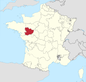
Anjou (French pronunciation: [ɑ̃ʒu]) is a former county, duchy (1360) and province centred on the city of Angers in the lower Loire Valley of western France. Its traditional Latin name was Andegavia.
Anjou, or then the Angevin march (border lands) formed the border between Neustria and Aquitaine. It also bordered between Neustria and Brittany. Sitting on a black slate rock was the Roman fortress of Angers. It guarded the rivers Mayenne and Loire that flowed around it.
- Related to anjou
- watch anjou videos on kidztube
- play anjou games
Post It On KidzTalk Homework Help
Report a search problem
home contact us settings advertise terms/privacyabout usteacher forum
View All
- COMPANY
- contact us
- settings
- advertise
- terms/privacy
- about us
- RESOURCES
- api services
- link to us
- add a site
- media/press
- education daily journal
- blocking websites
- teacher forum
- affiliate program
- make us your default search
- search help
- kidzsearch apps
- voice search
- LINKS
- home
- kidznet
- kidznet directory
- kidztalk
- kidztube
- games
- images
- top sites
- music
- facts
- news
- wiki
- boolify
- SOCIAL
desktop version
Powered by Google SafeSearch
Copyright 2005-2024 KidzSearch.com