Menu
-

Home
Homepage
KidzSearch
-

Games
Play Fun Mobile Games.
Games
-

KidzTube
Cool Videos for Kids.
Videos
-

KidzTalk
Talk About Anything
Q&A
-

KidzNet
Social Network for Kids
KidzNet
-

Pictures
Explore Popular Images.
Pics
-

Top Sites
Explore the Best Sites for Kids.
Websites
-

Music
Listen to Streaming Music for Kids.
Radio
-

Cool Facts
Facts for Kids.
Facts
-

Kids News
Read About Cool Topics.
News
-

Encyclopedia
Browse Over 200,000 Student Articles.
Wiki
-

Boolify
Learn How to Search with Boolify.
Boolify
-

Mobile Apps
Discover KidzSearch Apps
Apps


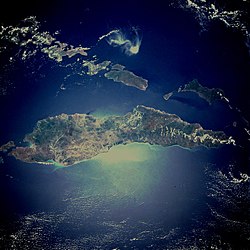
Timor is an island at the south end of the Malay Archipelago, north of the Timor Sea. It is divided between the independent state of East Timor, and West Timor, belonging to the Indonesian province of East Nusa Tenggara.
The island's surface is 11,883 square miles (30,777 km²). The name is a variant of timur, Malay for “east”; it is so called because it is at the east end of a chain of islands.
- Related to timor
- timor sea
- timor deer
- timor python
- timor wood totem
- timor sea oil spill
- timor sea map
- timor liste
- timor pythons
- watch timor videos on kidztube
- play timor games
Post It On KidzTalk Homework Help
Report a search problem
home contact us settings advertise terms/privacyabout usteacher forum
View All
- COMPANY
- contact us
- settings
- advertise
- terms/privacy
- about us
- RESOURCES
- api services
- link to us
- add a site
- media/press
- education daily journal
- blocking websites
- teacher forum
- affiliate program
- make us your default search
- search help
- kidzsearch apps
- voice search
- LINKS
- home
- kidznet
- kidznet directory
- kidztalk
- kidztube
- games
- images
- top sites
- music
- facts
- news
- wiki
- boolify
- SOCIAL
desktop version
Powered by Google SafeSearch
Copyright 2005-2024 KidzSearch.com