
Not Finding Your Answer?
Post It On KidzTalk Homework Help
Post It On KidzTalk Homework Help
Report a search problem

|
mobile version
Copyright 2005-2024 KidzSearch.com
|
|
| Hispaniola | |
|---|---|
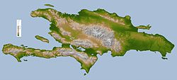 Topographic map of Hispaniola | |
| Geography | |
| Location | Caribbean Sea |
| Archipelago | Antilles |
| Area | 76,480 km2 (29,529 sq mi) |
| Highest point | Pico Duarte (3,087 m) |
| Countries | |
| President | Jovenel Moise |
| Capital city | Port-au-Prince (1,900,000) |
| President | Luis Abinader |
| Capital city | Santo Domingo (913,540) (Metro: 2,253,437) |
| Demographics | |
| Population | 20,113,564 (as of July 2013) |
| Density | 263 |
Hispaniola is an island in the Caribbean Sea. It is the second largest island (after Cuba) of the West Indies, east of Cuba and west of Puerto Rico.
The Republic of Haiti occupies the western three-eighths, the Dominican Republic the rest. Hispaniola is one of two Caribbean islands in which there are two countries; the other is Saint Martin.
view more...