
Not Finding Your Answer?
Post It On KidzTalk Homework Help
Post It On KidzTalk Homework Help
Report a search problem

|
mobile version
Copyright 2005-2024 KidzSearch.com
|
|
 | |
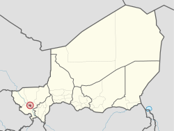 Location in Niger | |
| Coordinates: 13°30′54″N 02°07′03″E / 13.51500°N 2.11750°E / 13.51500; 2.11750Coordinates: 13°30′54″N 02°07′03″E / 13.51500°N 2.11750°E / 13.51500; 2.11750 | |
| Country | |
| Region | Niamey Urban Community |
| Communes Urbaines | 5 Communes |
| Districts | 44 Districts |
| Quartiers | 99 Quarters |
| Government | |
| • Type | Appointed district government, elected city council, elected commune and quarter councils |
| Area | |
| • Total | 239.30 km2 (92.39 sq mi) |
| Elevation | 207 m (679 ft) |
| Population (2012) | |
| • Total | 1,026,848 |
| • Estimate (October 1, 2020) | 1,334,984 |
| Niamey Urban Community | |
| Time zone | UTC+1 (WAT) |
Niamey is the capital city of the African country of Niger. It is Niger's largest city. The city is on the Niger River. Niamey is the administrative, cultural and economic center of the country.
The city is in a pearl millet growing region. Manufacturing industries in the city include bricks, ceramic goods, cement and weaving.
view more...